Mud from the Greenlandic seabed reveals a hidden past
Sea ice and bedrock shape key for glacier stability.
Satellite data and climate measurements spanning the last few decades are a treasure trove of information for scientists studying the Greenland Ice Sheet.
They clearly show that it is melting quickly in response to climate change. But how much will the Greenland ice sheet retreat in the future and how quickly could this occur?
These are the questions that occupy glaciologists and climate scientists today and this week we published the second of a set of studies that hold some of the answers.
Collectively we show how some glaciers may be more stable than previously thought, but also how in other cases declining sea ice could increase instability. We also demonstrate just how important accurate maps of the seabed are to understand this stability and predict how glaciers might behave in the future as the ocean and climate continue to warm.

Read More: New method identifies the most vulnerable glaciers in Greenland
Satellites are great but we need geology too
These questions are of great societal importance. Meltwater released from the ice sheet causes global sea levels to rise and can disrupt the Gulf Stream, with potential impacts on climate, and climate dependant industries such as agriculture and fisheries, in north-west Europe and Eastern USA.
Satellite measurements are extremely valuable for assessing ice sheet change, but they can only provide a brief snapshot of ice sheet behaviour.
In contrast, geological archives like ocean sediment cores, provide much longer records of climate, ocean, and glacier changes, and provide a valuable resource to understand how these systems interact.

For example, we know that there have been periods of warmth in the past, and by studying these we can understand how the ice sheet may react to future climate warming.
As part of our research project 'Past and future dynamics of the Greenland Ice sheet: what is the ocean hiding?' we analysed sediment cores—mud—collected from the ocean around Greenland to do just this.
Results from two of Greenland’s largest glaciers
Two new studies (here and here) from the research project have just been published in Scientific Reports; and present data from two deep fjords, Sermilik Fjord and Køge Bugt (Ikeq in Greenlandic), close to some of the largest outlet glaciers in southeast Greenland.
Access to the upper reaches of these fjords are hampered by year-round sea ice, icebergs, and frequent storms, which prevents most ships from reaching the front of the glaciers.
But we were able to collect samples from both and reveal history of these glaciers as far back as 9,000 years ago.
Read More: NASA project reveals vulnerability of Greenland glaciers
Study one: Køge Bugt Glacier more stable than previously thought
The first of our results focus on the Køge Bugt glacier system in southeast Greenland. Here, a large glaciated bay contains three of the largest glaciers in Greenland. These glaciers have lost a lot of ice in the past two decades, and have made the third largest contribution to sea-level rise from Greenland during this period.
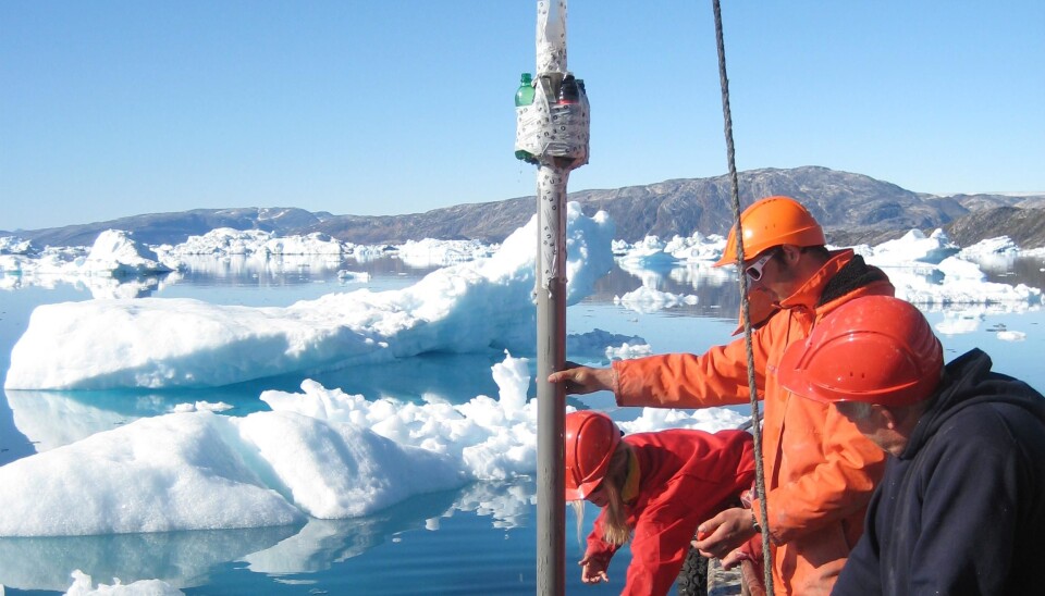
We travelled there in a small steel fishing boat to collect sediment cores in 2011 that date as far back as 9,000 years. It is the first such data collected from this largely unexplored and inaccessible bay.
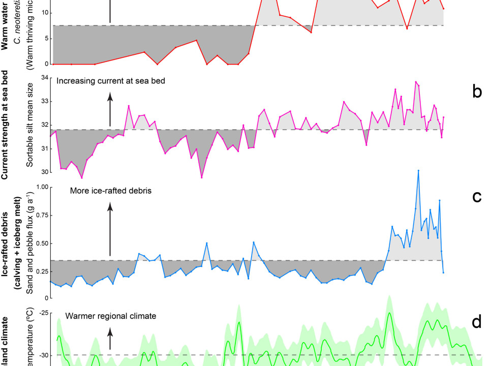
Studying the sediments, we found that between 9,000 and 5,000 years ago the deeper waters in the fjord were as warm as they are today due to warm waters from the Gulf Stream, which entered the bay and came into contact with the front of the glacier.
But despite these warm conditions, our cores also contained sand and gravel-sized sediment particles. These were scraped off the land by glaciers, and transported far from the coast by icebergs floating in the bay. We know this because sand and gravel cannot float freely in the water column for very long before they sink to the bottom, and certainly not where we took our cores, which was far from the coast.
So some agent must have transported them, and in this case it is icebergs. Icebergs only calve from the front of glaciers where they enter into the water, so this tells us that despite ocean warming 9,000 years ago, the glaciers did not retreat on land.
Read More: Glaciers are vital for Greenland’s fisheries
Køge Bugt glacier could be just as stable today
We calculated that the glaciers did not retreat more than six kilometres during this past warm period. This suggests that they could be just as stable today and we anticipate that they will remain so in the near-future, despite ongoing climate and ocean warming. You can see some of these data in the graph above.
This stability is attributed to the shape of the steep bedrock underneath the glaciers in Køge Bugt, which allows them to adjust to new conditions after retreating just a small amount. You can learn more about this in the video below.
Our findings demonstrate how individual glaciers are strongly controlled by the shape and depth of the fjord and glacier bed. And so good maps of these are important to accurately predict future glacier behaviour.
It also provides a baseline against which to judge future change as we now know that if the glaciers in Køge Bugt retreat out of the fjord and onto land, this would be unprecedented in at least the past 9,000 years.
Read More: How the Greenland ice sheet fared in 2017
Study two: 20th Century Helheim Glacier retreat is unique in the past 1,700 years
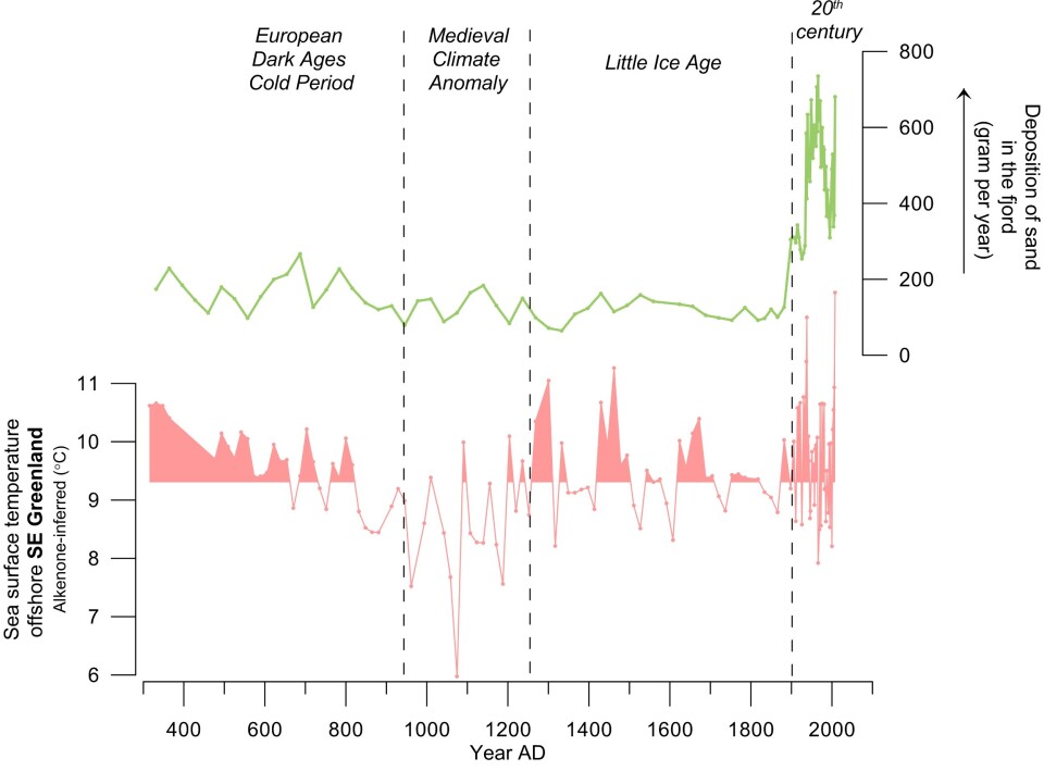
The study from Helheim Glacier had a slightly different focus. Here we studied the sediments from Sermilik fjord in southeast Greenland, into which Helheim Glacier terminates. The fjord contains biochemical compounds from the Irminger Sea, which allowed us to reconstruct past sea surface temperatures in this part of southeast Greenland over the past 1,700 years.
We saw that during the cold Little Ice Age (1300 to 1900 AD, a period of glacier growth and sea ice increase in Greenland), the waters in the Irminger Sea were surprisingly warm. They were actually as warm as it was during the 20th Century.
These waters circulate the fjords of Southeast Greenland and scientists think that they are very important in melting marine terminating glaciers. But what was even more surprising is, that despite this warming, our study indicates that the Helheim Glacier had a floating ice tongue--a sheet of ice protruding into the ocean, which once gone, may not leave any trace of its previous existence in the landscape. Today glaciers with such tongues only exist in much colder areas such as northern Greenland and Antarctica.
Read More: “Irreversible” glacier retreat in West Antarctica began 70 years ago
The reason we suggest that there was once an ice tongue here, is the markedly low amount of sediment delivered by icebergs that was recorded in our core at this time. This indicates that icebergs calved off the glacier had been deprived of their sediment as water melted the underside of the floating ice tongue.
Today, this tongue no longer exists. It broke up in the early 20th century when the amount of Arctic sea ice transported to Sermilik Fjord by the East Greenland Current (an ocean current) dropped to unprecedented low levels.
This indicates the importance of sea ice to effectively buffer the glacier against the effects of climate change. It does this by cooling the surface water and air temperature near the coast, which stabilises the front of the glacier. This helps to prevent icebergs being calved off the glacier, and hence reduces ice loss.
Read More: New report: how the Arctic will look in 30 years
Important implications for modelling glacier behaviour
Taken together, the results from both studies can be used to test the computer models that are used to predict the future behaviour of glaciers in Greenland. After all, if a computer model is not able to simulate the past glacier changes, we should question its ability to accurately predict their future.
Specifically, the results underline that using models for future predictions requires a detailed knowledge of the bedrock topography beneath glaciers as well as information on the future extent of sea ice.
Doing this will allow us to identify possible thresholds in the natural system, such as the loss of sea ice, which once crossed could cause dramatic glacier retreat.
Glaciologist Laurence Dyke from the Geological Survey of Denmark and Greenland discusses his new research in Scientific Reports. (Video: Laurence Dyke)
---------------
Read this article in Danish at ForskerZonen, part of Videnskab.dk
The research project 'Past and future dynamics of the Greenland Ice sheet: what is the ocean hiding?', is supported by the VILLUM Foundation. Read more on the project website.
Scientific links
- Dyke et al. (2017) Minimal Holocene retreat of large tidewater glaciers in Køge Bugt, southeast Greenland. doi:10.1038/s41598-017-12018-x
- Andresen et al. (2017) Exceptional 20th century glaciological regime of a major SE Greenland outlet glacier.


