Once lost archaeology revealed by satellite images and aerial photography
Using a high tech approach, archaeologists have turned back time and reconstructed a hidden urban landscape in Jerash, Jordan.
How do you study ancient cities when they’re hidden from view, covered with hundreds or thousands of years of human development by the growth of towns and cities?
For archaeologists like us, it’s a constant dilemma.
Recently, we joined forces with archaeologists and geoscientists in Denmark and Germany to tackle this challenge.
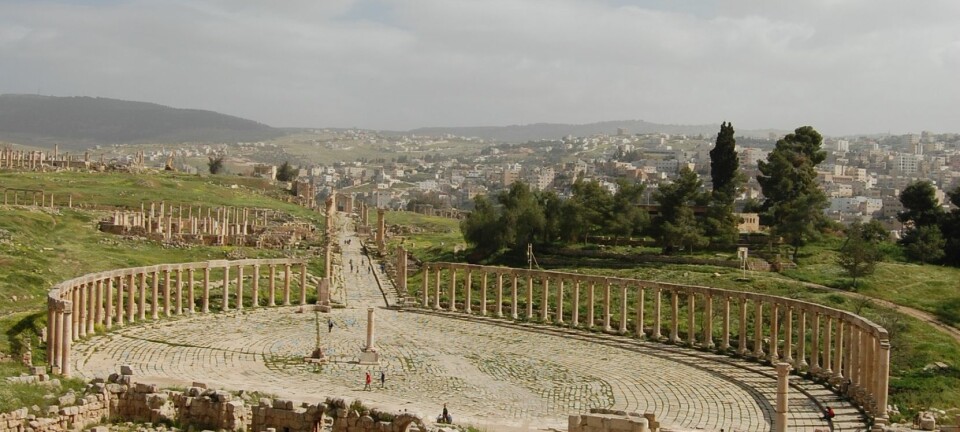
For the first time, we have mapped archaeological and non-archaeological features of the ancient city Gerasa (modern-day Jerash in northern Jordan) with extreme accuracy and precision.
We combined historical images with state-of-the-art aerial photography and modern airborne laser scanning, to turn back time and reconstruct the landscape and archaeological features no longer visible due to modern urban development.
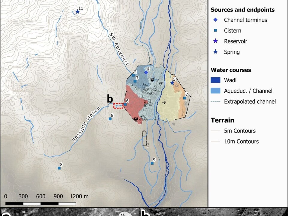
This combination of older and new data reveled lost monuments, which until now have not been recorded firmly in the archaeological record, including possible aqueducts and water channels. And suggests that ways of managing water in ancient Gerasa changed profoundly over time, as a result of changing settlement patterns and ways of managing the hinterland.
Read More: Archaeologists: Cities deserve better treatment
An important city destroyed by an earthquake
Gerasa was an important city in the eastern Roman Empire, until it was destroyed by a devastating earthquake in 749 CE.
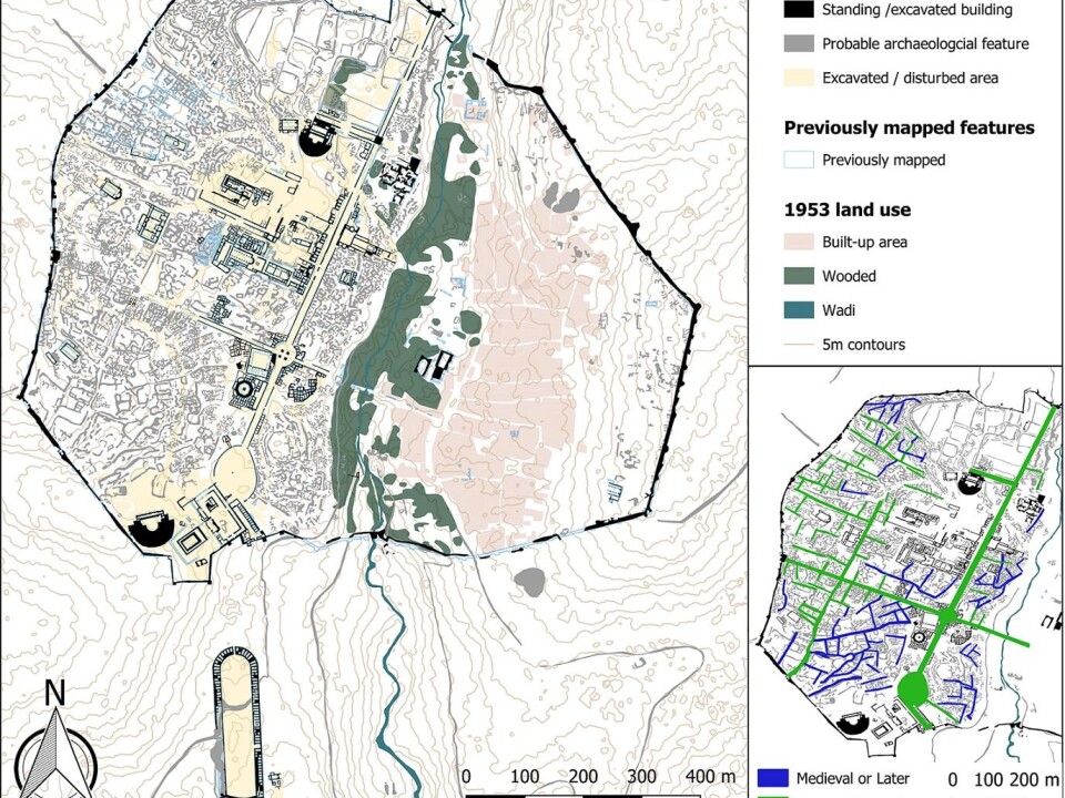
It held splendid monuments and structures, which testify to a vivid urban life influenced by many cultures over the course of centuries. The ancient city covered an area of approximately 90 ha, encircled by more than 4 kilometres of city walls.
After the earthquake, life diminished in the city and only in the Middle Islamic period (starting in the 12th century CE) did settlement take place on a larger scale once again.
Read More: High definition archaeology reveals secrets of the earliest cities
A popular site for 19th century archaeology enthusiasts
The first excavations are documented to have taken place in Gerasa in 1907. These early excavations uncovered a splendid mosaic, which today is spread across the world in a number of collections, including the Pergamon Museum in Berlin. It testifies to the level of craftsmanship in Roman period Gerasa.
Many European travelers visited the site in the 19th and 20th centuries and several descriptions of many lost monuments are to be found in accounts of these travels, which give an insight into contemporary society and life in and around Gerasa.
The first major excavations in Gerasa were, however, undertaken as late as the 1920s and 1930s by an American-British archaeological mission headed by the Yale scholar C. H. Kraeling. Since then, several teams have worked in Gerasa, but still large parts of the city remain archaeologically unexplored and are now threatened by modern destruction, such as looting and modern developments around the site.
Read More: Archaeologists develop new technology to read ancient documents
A puzzling site
In 2011 we established the Danish-German Jerash Northwest Quarter Project. And from day one, we were puzzled by several of the archaeological findings at Gerasa.
Monumental water cisterns were found closed off and falling out of use indicating urban decline or at least significant changes in the management of public works, while at the same time domestic habitation flourished in the Late Antique and early Islamic periods.
These archaeological finds indicated that crucial changes were taking place in the landscape around ancient Gerasa (modern Jerash) in the 5th to 8th centuries CE, but we couldn’t pinpoint them through the excavated finds alone.
Wanting to explore the area around Gerasa, we teamed up with Søren Munch Kristiansen from the Centre for Urban Network Evolutions and GeoScience at Aarhus University, Denmark, as well as David Stott from Archaeological IT and Moesgaard Museum, and we also paid a visit to the Royal Jordanian Geographic Society.
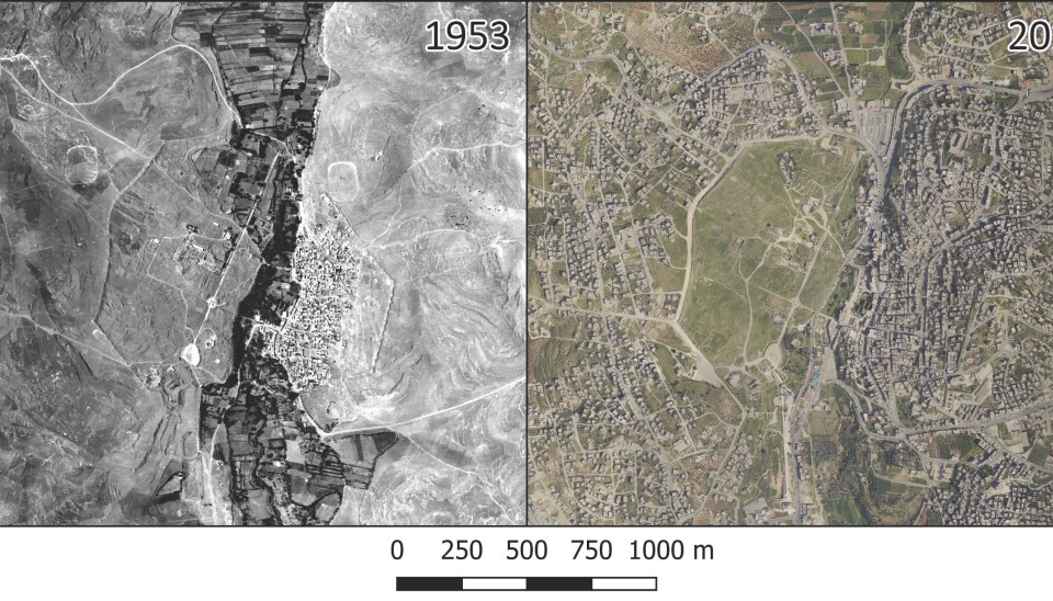
We learned that LiDar data for use in archaeological projects could be accessed through the Department of Antiquities of Jordan. So, with permission in hand, we bought the LiDar data, and the team began to collect historical photographs dating back more than a century. We also obtained satellite images documenting modern day development at Jerash.
By combining the LiDar data with the satellite images and the historical photographs, we were able to identify previously unknown structures, including possible aqueducts, channels, springs, and cisterns, and map them in relation to possible areas of water supply within the city.
Read More: Dead Sea Scrolls still conceal many stories
We lacked the “big picture” of change in Gerasa
The Danish-German Jerash Northwest Quarter Project started as a large-scale interdisciplinary excavation to explore the approximately 4 ha large Northwest Quarter, located on the highest bedrock point within the walled city.
Since then, we have systematically recorded evidence of the city’s urban development, and we’ve now published several studies as part of the project, which focus on a variety of aspects of urban life in antiquity and beyond in the city of Gerasa. But so far, none had managed to paint an accurate ‘big picture’ looking at the city in a more holistic way.
These most recent results – based on integrating historical aerial photos and modern technology – offer further insights into the urban layout and infrastructure of Gerasa.
For example it has become clear that the ways of managing water in the hinterland around Gerasa had changed dramatically over time, and that these changes may have been due to climatic factors. Such changes are often attributed to the 8th century CE as outcomes of the devastating earthquake of 749 CE, but our new data suggest that they actually began centuries earlier than previously thought.
Read More: Ancient grain reveals the development of the earliest cities
A high-tech approach can help preserve ancient sites
The novelty of our approach is that it integrates World War I photos, contemporary mm-precise 3D-laser scanning, and decades of scattered archaeological excavation data to produce a detailed map of how an entire ancient city in the Middle East appeared before modern destruction and urban encroachment began.
In many parts of the world, population growth and climate change pose urgent risks to cultural heritage sites. Archaeologists and heritage workers are in a race against the clock to document and understand the life of past societies before the historical remains are irreversibly destroyed.
Non-invasive approaches to map archaeology is a crucial part of this endeavor, allowing us to turn back time and document destroyed and lost monuments that connect us with the past. Furthermore, they offer access to document multi-layer and multi-temporal sites, giving credit to all periods.
Our study shows that bringing scholars and experts together from a variety of disciplines is one important way forward, especially at sites where modern urban development is taking place rapidly and partly uncontrolled. Such an interdisciplinary approach offers a particularly important support for on-going or planned archaeological work.
---------------
Read this article in Danish at ForskerZonen, part of Videnskab.dk