3D-model will reveal events surrounding Greenland landslide and tsunami
Surveys of the West Greenland landslide identify a vulnerable mountain slope that is still active.
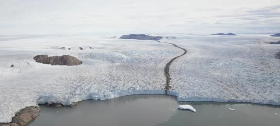
On the evening of June 17, a 90-metre high tsunami—one of the tallest tsunamis on record—swept up the Karrat Fjord in West Greenland, carrying large ice bergs, destroying houses, and with four people still missing—presumed dead.
The cause of the tsunami was quickly identified as a landslide that brought large amounts of rock tumbling down the mountain into the fjord. When the rocks hit the ice and water approximately 1,000 metres below, it created the mega tsunami.
The tsunami dissipated as it travelled up and across the fjord, but retained enough power for ten-metre high waves to devastate the fishing village of Nuugaatsiaq, about 30 kilometres away.
Scientists from the Geological Survey of Denmark and Greenland (GEUS) have now surveyed the area and are developing a high-resolution 3D model of the mountain slope before and after the event to understand precisely what happened.
“The landslide occurred in an area where we are conducting a multi-year geological mapping project,” says Stefan Bernstein head of the Department of Petrology and Economic Geology, GEUS, who participated in the fieldwork.
“We’ve now finished the last field trip in July and August this year, where we took photos by helicopter and ship. Once we’ve calibrated the photos and processed them in the laboratory, we can make a precise estimate of how the landslide occurred, identify which geological structures were key to the event, and make a very precise estimate of the volume of rock that came down and how much fell into the fjord,” he says.
Bernstein and colleagues returned from the field last week and hope to have the 3D-model finished by the autumn.
Landslide occurred in a well-surveyed region
GEUS have been able to study the event in some detail as it occurred in an area that they were already mapping as part of a project to assess the economic potential of geological deposits in the region.
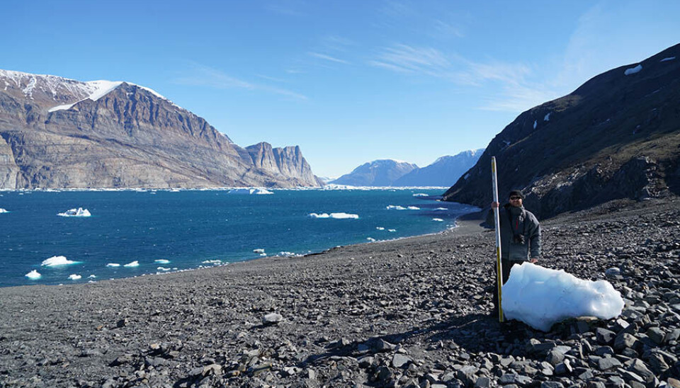
Bernstein and colleagues conducted surveys in 2015 and 2016, where they collected approximately 36,000 high resolution photos between the two remote towns of Uummannaq and Nuugaatsiaq, where the tsunami hit, on the west coast of Greenland.
“This landslide just happened to occur right in the centre of our research area, and so we have good footage of the wall before and after where the landslide occurred,” says Bernstein.
Risk of a second landslide nearby
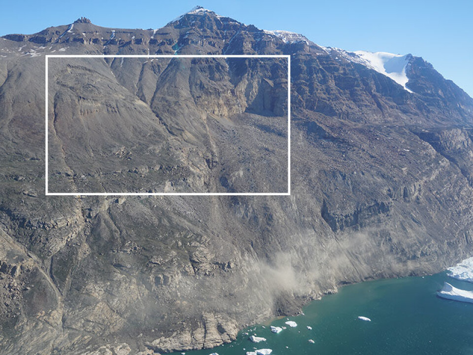
Their surveys have already identified some of the key geological features that make the area particularly vulnerable to landslides, says Bernstein.
“From what we see up to now, it confirms our initial interpretation that there are certain weaknesses from geological structures that play a major role in making this part of the mountain wall unstable,” he says.
They identified the original bedding planes of the metasedimentary rocks that make up the mountain slope. These ancient rocks are 1.8 to 2 billion years old and are deposited in layers that dip steeply towards the fjord. This forms surfaces that act like a slide in a playground—a predefined geological weakness that makes the slopes vulnerable to rock falls.
They have also identified another area at risk of collapse, adjacent to where the June landslide occurred.
“Both areas where the landslide occurred and the new risk area towards the west are still very active,” says Bernstein. “There’s still small rock falls around the rim of the new risk area situated about 1,000 metres west of the June landslide, and it still showed activity when we were there around July 25th.”
Survey results confirm initial assessments
The event has attracted international attention and research groups from elsewhere have also studied the landslide. Professor Hermann Fritz form the Georgia Institute of Technology in the USA and colleagues visited the area in early July.
Together with colleagues from a private engineering company in Canada, they have already developed a preliminary 3D-model of the mountain as it appeared soon after the landslide.
Their model provides an initial view of the landslide and the new area of risk, adjacent to it. It also provides an estimate of the volume of rock that fell into the fjord and the size of the affected area.
You can see their results in the video below.
GEUS model will improve initial rock fall estimates
Their model illustrates the event well, says Flemming Getreuer Christiansen, Deputy Director of GEUS.
“It’s very important to understand what happened so you have a basis for modelling and evaluating future risks. They calculate 46.9 million cubic-metres of rock fell into the fjord, I’ve heard numbers from at least 30 up to 70 million cubic metres. So all of them are in the same order of magnitude, but it’s still a large range,” says Christiansen.
GEUS aim to produce a higher resolution model that will narrow down this uncertainty and improve their understanding of the risk of future landslides, says Christiansen.
“The key question now is: What is the risk today for additional landslides, knowing that there is a critical feature sitting there on the same mountain? Most people working on landslides agree it is a high risk area and that it will fall down, but whether that will be in one big piece, or several smaller pieces, or how much material it will take with it, is difficult to say,” says Christiansen.
A preliminary 3D-model of the mountain side after the landslide as it appeared in early July. (Video: Hermann Fritz / Scott Anderson)
The 3D-model being developed at GEUS will help to answer some of these questions. Though they are unlikely to be able to predict precisely when a future landslide could occur, he says.
Locals still not permitted to return home
The fieldwork follows a period of intense work by scientists at GEUS and the ASIAQ Greenland Survey in the immediate aftermath of the landslide and tsunami. During which, advice was issued to the emergency committee led by the Greenland Government.
“Here at GEUS, 15 to 17 people have been involved, including myself. And we have been in contact with around 25 scientists and consultants from around the world, especially in the USA, Norway, and Switzerland. We’ve had a lot of help from the scientific community to interpret data—especially seismological data collected immediately after the event,” says Christiansen.
In light of this, the Emergency Service Commission advised residents of Nuugaatsiaq and the nearby settlement of Illorsuit that they could not return to their homes due to the risk of a further landslide and tsunami.
Almost two months on, residents of Nuugaatsiaq and Illorsuit are still not permitted back.
“The problem is that when the landslide occurred, it only left eight minutes before the tsunami hit. So it doesn’t leave any time to implement an early warning system and that’s one of the reasons why it’s not safe for anyone to move back,” says Bernstein.
GEUS will complete an analysis of landslide risks throughout all of Greenland, focusing on areas of settlement and industry, later this year.