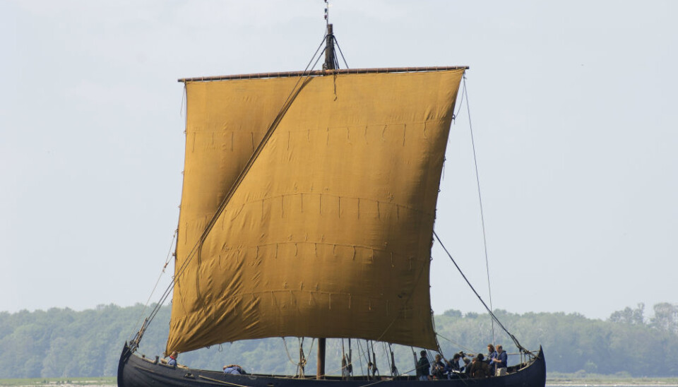
How Vikings navigated the world
With no access to modern navigation instruments, Vikings relied on birds, whales, celestial bodies, chants and rhymes to navigate the seas and discover new land.
Today it seems like a bit of a mystery how our savage forefathers managed to navigate their way across the Atlantic centuries before Columbus discovered America.
Maybe it’s because they weren’t as dumb as some of us think. They understood how to link their travel stories and sensory impressions with observations of wind, weather, wildlife and solar time. This enabled them to figure out which way to go.
Experience helped Vikings understand nature
In order to understand the Vikings’ way of travelling, we need to rid ourselves of our current conception of nature and navigation:
“Back then, there were of course no compasses, echo sounders, satellite navigation or radio communication,” says Anton Englert, a PhD in archaeology who researches into Viking Age seafaring at the Viking Ship Museum in Roskilde, Denmark.
“The Vikings had an understanding of nature, since they lived in the wild. But their observations didn’t lead to any scientific data that they could use to construct precision tools.”
They knew of the concepts of east, west, south and north. But to them, navigation was more based on where on the horizon the sun rose and how high it was during the day, rather than Earth’s magnetism, which underlies the modern compass.
Vikings used landmarks and mental charts
The sun, the moon and the stars provided the Vikings with a decent understanding of which direction to travel.
But in fog and cloudy weather these celestial bodies are not visible, and on long stretches, a deviation of only a few degrees from the planned route can mean that you end up completely missing your intended destination.
For this reason, the Vikings also kept an eye on objects on land when they sailed along the coasts. A rock with a particular shape, for instance, or a hilltop, could provide some clues to where they were.
Chants and rhymes showed the way
Since there were neither nautical charts nor any written descriptions back then, the Vikings’ travelogues consisted of narratives and rhymes.
An example of these travelogues can be found the medieval Norse manuscript ’Hauksbók’:
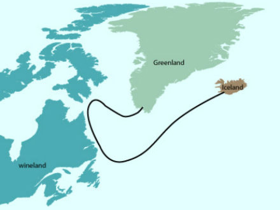
"From Hernam [present-day Hennø near Bergen] in Norway, head due west towards Hvarf in Greenland, and you will have sailed north of Hjaltland [the Shetland Islands}, so that you just glimpse it in clear weather, but south of the Faroe Islands, so that the sea [the horizon] is right in between the distant mountains, and thus also south of Iceland.”
In other words: they sailed from Hennø in Norway, heading due west towards Greenland, between Shetland and the Faroes and south of Iceland.
Birds and whales served as navigation marks
When out sailing, the Vikings used wildlife as landmarks. Birds were particularly helpful, since some birds only flew a certain distance away from land.
If for instance they had long since passed the Faroes and saw a particular terrestrial bird, this could be a sign that they were near Iceland.
Whales usually stay close to currents where fish can be found. The Vikings knew where whales typically resided, and this knowledge helped them figure out where they were in relation to e.g. Iceland.
Vikings navigated with their senses
A common hypothesis in research circles is that Vikings used their senses to navigate. In addition to the obvious one – sight – they also made use of:
- Hearing: The Vikings could hear how close they were to land when it was too foggy to see. They kept an ear out for the screeching of birds and the sound of waves breaking on the shore.
- Touch: The sense of touch in our faces can be used to register changes in the speed and direction of the wind. This sensation can reveal differences between wind swells from various directions. And since nearby coasts can reflect swells back, a seasoned Viking could extract a lot of information just from a sea breeze.
- Taste: One of the few navigation instruments the Vikings had at their disposal was a plumb bob, which they used for assessing the depth of the water. The plumb bob also collected a tiny sample of the seabed, which the men could then taste and touch. An experienced sailor could link the taste to other characteristics. It’s likely that the Vikings have been able to determine, using only their taste buds, if fresh water flowed from land into the sea water.
- Smell: A seasoned mariner can smell whether or not he’s close to land. In humid conditions, the human nose is capable of detecting trees, plants and fire some distance from land.
Weather: an aid and an obstacle
Being the great seafarers that they were, the Vikings were probably great at observing weather patterns – for instance how a low pressure passed on a particular route. This helped them determine which direction to go.
Englert mentions an example of this:
“Your sails are filled with southern wind and rain, so that you’re sailing with the wind abeam from the board side towards the west. Your experience tells you that the rainy wind usually flows clockwise. To maintain the course on the high seas, the Vikings could then gradually trim the sails to keep them from luffing in periods when the sky was cloudy and neither the sun nor the stars were visible.”
Courage and poor soil lured Vikings across the Atlantic
Morten Ravn, who researches into Viking ships at Copenhagen University, mentions three possible explanations to what compelled the Vikings to go looking for new land as far out to sea as they did.
- Coincidence: The Vikings’ navigation was far from accurate, which also explains why so many of their ships ended up on the bottom of the sea. But some of them found land and named it – for instance Iceland and Greenland.
- Recognition and respect: It took courage to sail out and look for new land, and this gave prestige.
- Lack of inheritance: A lack of inheritable land among the sons of farmers and magnates may have motivated them to find new land to conquer.
Anton Englert adds another possible explanation: banishment. He says that some of the sagas mention Norwegians who had become unpopular with the establishment at home. They went looking for places to settle down and enjoy their freedom.
The cold climate in the Faroes, Iceland and Greenland didn’t scare off the Vikings because it wasn’t much different from the Norwegian climate.
“Their familiarity with the North Atlantic climate and poor soil in Norway turned the Vikings into maritime people who looked for a better life on the other side of the ocean.”
America was discovered by chance
According to one historical source, Grænlendinga saga (The saga of the Greenlanders) America was discovered by accident in the autumn of 996 AD.
The saga tells the tale of Bjarni Herjólfsson, who is believed to be the first European to see North America when he set sail for Greenland to meet his father.
“Bjarni Herjólfsson had learnt how to sail to Greenland from Norway, but his ship encountered several days of strong northerly wind and fog,” explains Englert. “His ardent efforts to keep the ship afloat resulted in his ship being blown off course.”
The discoverer of America was mocked
In his efforts to get back on course, Bjarni Herjólfsson tried to sail due west again. He eventually saw a piece of land [North America], but this land was more fertile than the Greenland he had heard about.
His crew wanted to go ashore, but Herjólfsson insisted on reaching Greenland before the end of the sailing season. So he headed north and there he noticed that the land was becoming less fertile and rockier.
After a while he saw land that resembled what he had been told about Greenland and eventually he landed near the place where his father lived.
“Bjarni Herjólfsson was not credited for having found new land. Rather, he was mocked for not having gone ashore {in America],” says Englert.
Although he passed on his findings in Greenland, there was little interest in his reports until, after his father's death, he returned to Norway.
Here, Herjólfsson’s travel tales inspired Leif Ericsson to mount his own expedition to Greenland. He bought Herjólfssons ship and manned it with 35 crew members.
In the year 1002, Ericsson discovered North America. Here, he found grapes and berries, which is why he decided to call it Wineland. The rest we’ll have to leave for another time.
--------------------------------------
Read the Danish version of this article at videnskab.dk
Translated by: Dann Vinther