“Treasure trove” of Arctic research data now publicly available
Twenty years of Arctic research can help scientists around the world better understand climate and environmental change.
Ever wondered how many musk oxen there are in Greenland? Or how populations of spiders and insects have changed in recent years? Want to see if there is a link between snow cover and temperatures? Well, now you can find out for yourself.
Scientists have been collecting data on everything from snow cover, wind, rain, temperatures, fjord water chemistry, glaciers, and populations of musk oxen, spiders, insects, birds, and more from around Greenland for decades.
They have steadily built up a database of all of their observations by returning to the same locations, time and time again to measure the exact same thing, in the exact same way.
It is laborious and repetitive work but the result is a treasure trove of data that is helping scientists from across the world to better understand changes in the Arctic, says program leader Torben Røjle Christensen from Aarhus University, Denmark.
“We now have a twenty-year record of operational data that cannot be found anywhere else in the circumpolar north. As a coordinated program it’s unique,” says Christensen.
Read More: Calling all armchair scientists: ESA releases Greenland satellite data
Free data for researchers, students, or interested citizens
All of the data are now freely available online at the GEM website and a summary of the most significant discoveries from the past year is available in the recently launched Annual Report Cards.
“Anyone can go in and download the data. There’s a boatload available,” says Christensen—more than 1,500 parameters to be exact.
They already have around 180 registered users from around the world—mainly researchers who are aware of the program.
Now, the goal is to reach the education sector, says Christensen, who hopes that university students and school teachers will use the data.
If you need some inspiration, here are five recent discoveries from the GEM database.
Read More: Take a tour of an Arctic monitoring site
1) Glacial melt from Greenland is making the sea fresher
A recent study presented the first long data series that documents the impact of melting ice on the chemistry of a fjord in Northeast Greenland.
One question posed by climate change is ‘will melting land ice and sea ice in the Arctic slow down or even shut down a vital part of the ocean circulation in the North Atlantic?’
If it did, the consequences could be severe and possibly even cut off the supply of mild, wet weather to north and west Europe.
Whether or not this is already under way is a contentious topic, but one clear indication would be a long-term reduction of temperature and salinity in the seas around Greenland.
“This is just what we saw,” says lead-author Mikael Sejr from Aarhus University, Denmark.
“We looked at two of the most basic parameters, it’s as simple as it gets: the temperature and salinity of water in a Greenland fjord. But it’s a game changer,” says Sejr.
They studied 13 years’ worth of GEM data and saw a fourfold increase in fresh water to Young Sound in Northeast Greenland associated with melting glacier ice further north.
“It isn’t surprising, but it’s the first long data series to show it,” says Sejr.
The next step is to see how far this freshening extends in the seas around Greenland, he says.
Read More: Is a vital pattern of ocean circulation about to shut down?
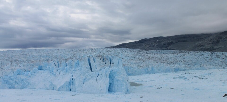
2) Greenland’s glaciers are melting faster than the ice sheet
Independent of the Greenland ice sheet, there are approximately 19,000 individual glaciers scattered around Greenland. Scientists are monitoring five of these, three of which are part of the GEM network.
These 19,000 glaciers cover a relatively small area—just five per cent of all ice-covered land in Greenland—but studies over the past decade using monitoring data from GEM among others, have shown that they contribute up to 14 per cent of all ice loss from Greenland.
Some of these glaciers terminate in fjords, where a recent study demonstrated their importance for maintaining some of Greenland’s most productive fisheries.
Read More: Glaciers are vital for Greenland’s fisheries
GEM scientists monitor snow and ice at one of their permanent monitoring sites in Kobbefjord, just outside Nuuk, Southwest Greenland. (Video: ScienceNordic)
3) Frozen soils “push” methane out of the tundra
Shortly after the Zackenberg Research Station was established in Northeast Greenland, scientists observed a phenomenon that had never been seen before: frozen tundra releasing more greenhouse gas than thawing tundra.
We often hear that thawing permafrost is a ticking time bomb that could release large quantities of greenhouse gases into the atmosphere, further exacerbating global warming. But the ability of frozen soils to emit large quantities of methane gas was entirely new.
“Nobody knew this before. We first had a chance to measure it in 2007 and 2008, and since then it’s received a lot of scientific attention,” says Christensen, who has subsequently observed similar events in Alaska and Svalbard.
Their measurements at Zackenberg showed that more methane was released during a single event than all of the preceeding summer. It was caused by frozen soils sitting above permafrost, which created enough pressure to “push” the methane out of the tundra.
Subsequent monitoring showed the effect to be much smaller and variable in the following years.
“It doesn’t happen every year, so we need to have these long time series to see these events. Otherwise, we don’t have a complete picture,” says Christensen.
Read More: One quarter of the Arctic is a hotbed for overlooked greenhouse gas
4) The Arctic is more dynamic than previously thought
Scientists have captured other extreme events as part of the GEM network.
On the 11th April 2016, a series of avalanches occurred across Kobberfjord, just outside Nuuk in Southwest Greenland. The events were triggered by a period of intense rainfall and a rapid rise in temperatures, which rose by 27 degrees centigrade in a little over two days. This initiated a flow of slushy snow, churned up with mud, rocks, and vegetation, in what the scientists called a slushflow.
The event caused the water level of a nearby lake to rise rapidly to its second highest level on record and took out some of the monitoring equipment installed at the Nuuk site.
"We coincidentally observed this rare event during one of our regular monitoring tours and are now benefiting from the wealth of ground-based GEM data available during this period" says Jakob Abermann from Asiaq Greenland Survey, and the lead scientist of ClimateBasis—the climate monitoring sub-program of GEM.
Abermann and colleagues are now assessing the spatial scale of this event using high-resolution satellite images, and have since identified several hundred similar slushflows from the same event.
Read More: Arctic plants may be tougher than you think
5) Remote sensing improves records of temperature, soils, and vegetation across Greenland
Many locations in Greenland are inaccessible, so GEM scientists are finding ways of getting around this hurdle by combing their field research with satellite imagery to develop countrywide records of temperature and vegetation, and to develop local records of surface moisture.
The data series will help answer some key questions in the Arctic and hopefully raise some new ones, says Andreas Westergaard-Nielsen, an assistant professor at the University of Copenhagen, Denmark, who is involved in the GEM remote sensing initiative.
“You could use these data to estimate methane production across Greenland. To do this you want to know soil moisture conditions at the sites where you have methane measurements, then with the surface moisture dataset you can scale that relationship up to landscape scale,” he says.
“You could also look at time series of vegetation. There’s a long running debate as to where the Arctic is greening and the reasons behind it. Here, you can collect the vegetation data and relate it to local measurements of species. By combining these data, you can start asking questions of how vegetation is changing across Greenland. Is it individual species or all vegetation?” he says.
Westergaard-Nielsen expects to have the first results of the remote sensing project ready by the end of 2017.
Take a tour of one of the GEM permanent field sites, just outside the Greenlandic capital city, Nuuk.
Scientific links
- GEM project website
- GEM database
- Evidence of local and regional freshening of Northeast Greenland coastal waters. 2017. doi:10.1038/s41598-017-10610-9